ferzerz5-lab
survey-desk
Exact land-survey computation for Hermes Agent. LLMs are unreliable at bearings, closure error and datum shifts. This plugin gives Hermes a survey desk that computes them exactly, checks its own work, and sends the plan back in chat.
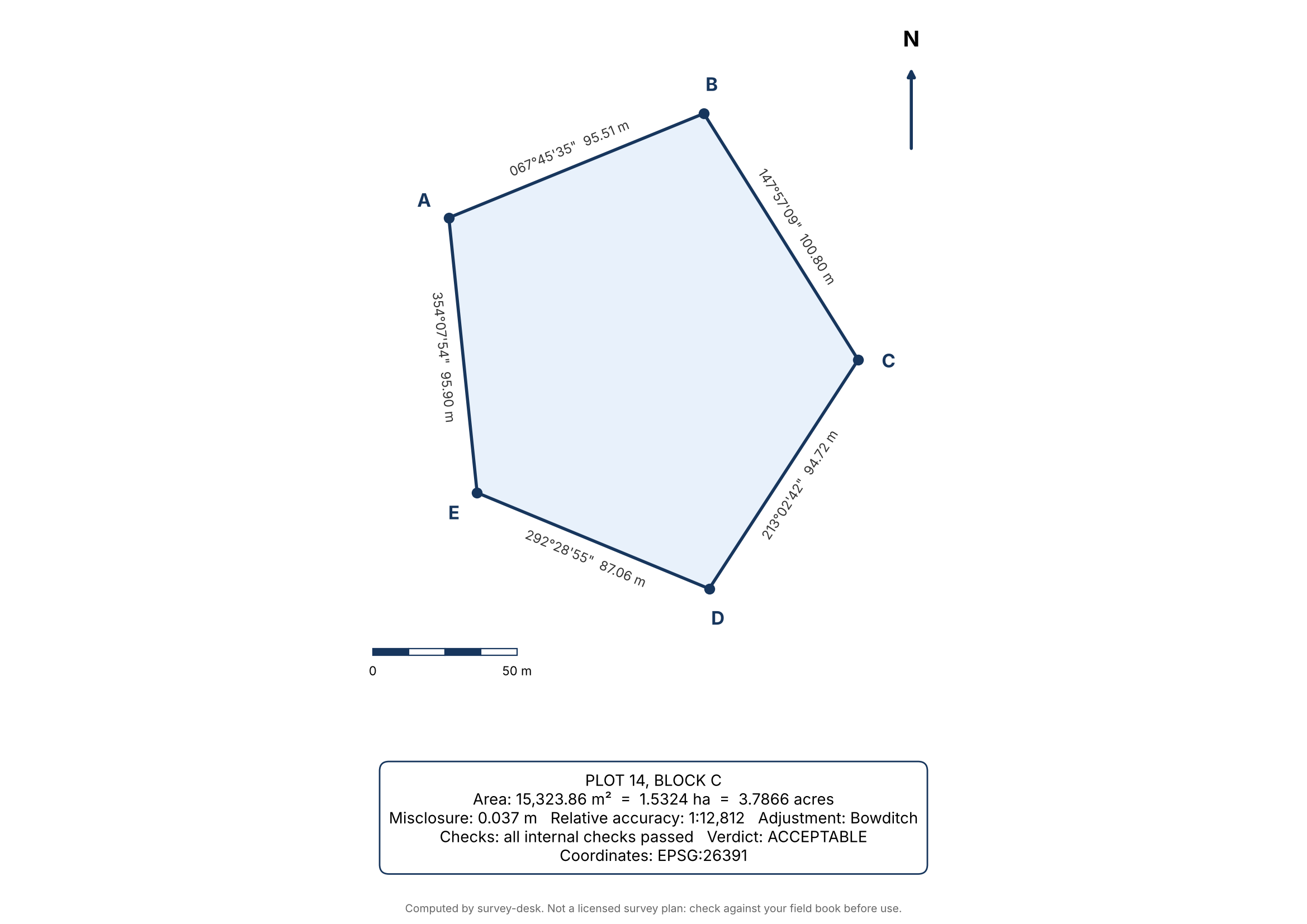
Send a field book from Telegram, get back a drawn plan, a DXF for CAD, and a KML you can open in Google Earth.
What it does
| Tool | Job |
|---|---|
| survey_traverse | Closed-traverse computation: misclosure, relative accuracy (1:N), Bowditch or transit adjustment, adjusted coordinates and bearings, area (m², ha, acres). |
| survey_plan | Same computation plus a drawn plan (bearings and distances on every line, beacons, north arrow, scale bar, area box) exported as PNG, PDF, DXF, and, when a CRS is given, georeferenced KML and GeoJSON. |
| survey_convert | PROJ coordinate conversion between WGS84, Minna datum, Nigeria West/Mid/East belts, UTM zones, or any EPSG code. |
| survey_inverse | Bearing and distance between two coordinate pairs. |
Also a /survey slash command (paste a field book, get the summary and files) and a bundled field-book skill that tells the agent to use the tools instead of doing survey arithmetic itself.
It checks its own work
Every traverse runs these checks and reports them:
- Closes after adjustment: the adjusted traverse returns to the start station.
- Two independent area methods agree: coordinate (shoelace) method vs double-meridian-distance method.
- Simple polygon: the boundary does not cross itself (a mis-ordered station list gives a plausible but wrong area; this catches it).
- Meets tolerance: relative accuracy against the limit you set (default 1:5000).
When a traverse fails tolerance, the plugin names the leg most likely to hold the blunder and the value it probably should have been. Each leg is tested two ways: a wrong distance leaves a misclosure parallel to the leg; a wrong bearing rotates the leg and leaves a chord-shaped misclosure. Example on the bundled demo field book, after a digit transposition in a distance:
Misclosure 9.037 m, relative accuracy 1:51
Suspect leg D-E (distance): 78.05 -> 87.087 (distance looks 9.037 m short, fit 100.0%)
The true value was 87.05. These are ranked candidates, not proof: symmetric or parallel legs can explain a misclosure equally well, and the plugin says so when that happens. Re-measure the top leg before changing the record.
Field-book format
title: Plot 14, Block C
crs: minna_west
start: A 164500.00 380200.00
A-B 067-45-46 95.52
B-C 147-56-59 100.81
C-D 213-02-26 94.72
D-E 292-28-56 87.05
E-A 354-08-08 95.90
Bearings are whole-circle (067-45-46, 067°45'46", 67.7628) or quadrant (N67-45-46E). Distances are metres. The last leg returns to the start station. Optional lines: method: transit, tolerance: 10000. See examples/demo-fieldbook.txt.
Coordinate systems
Aliases: wgs84, minna, minna_west, minna_mid, minna_east, minna_utm31, minna_utm32, utm31n, utm32n, or any EPSG code (EPSG:26391). Geographic points are longitude (x), latitude (y).
survey_convert and the KML/GeoJSON export are honest about limits:
- They report the exact PROJ operation used and its published datum-shift accuracy (for example Minna to WGS 84 is about ±15 m in the west). A parcel placed on Google Earth is only as accurate as that shift.
- They warn when points fall outside a CRS's area of use (Minna UTM 31N, for instance, only covers the far south).
- They do a round-trip check on every conversion.
Limits
- v1 handles closed-loop traverses in metres. Link traverses between known points, angle-based input, and levelling are not included.
- The default tolerance of 1:5000 is a placeholder. Set the limit your surveying authority requires.
- Output is a computation aid. It is not a licensed survey plan, and the drawing says so.
Disclosure (catalog rule 13)
- Network calls: none. PROJ network access is off by default and is not enabled.
- Reads outside the plugin's data: none. Plans are written to
<hermes home>/plugin-data/survey-desk/plans/. - Shell commands, background processes, stored credentials, telemetry: none.
- Dependencies (declared in
pyproject.toml, with upper bounds): pyproj, matplotlib, ezdxf.
Install and test
hermes plugins install survey-desk
From a checkout:
pip install -e . pytest
python -m pytest tests
hermes plugins validate . --install-deps
hermes plugins doctor . --ci
License
MIT
README from the reviewed commit 0e2e45b; it updates when the author re-pins.